Over the past million years Britain’s climate has fluctuated from balmy Mediterranean-like conditions to periods of glaciation. During the Palaeolithic (c. 3.3 million years ago – 10,500 BC), there were at least ten separate waves of human occupation as people were repeatedly driven out by successive ice ages. At this time, Britain still formed part of mainland Europe with the Irish Sea, the North Sea and the Channel then an expanse of low-lying grassland or tundra. Early humans would only have visited this far flung corner of Europe between glacial periods following migrating herds of woolly mammoth, woolly rhino and reindeer. Although the Sussex Downs, along with much of southern England, often escaped glaciation, it would still have been a cold, treeless and inhospitable landscape during successive ice ages.
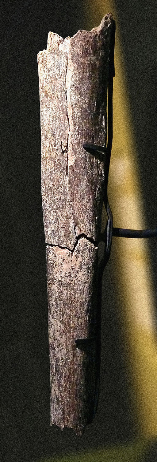
The earliest fossil evidence of a human presence in Britain has been found in Sussex. A leg bone and two teeth from the tall, imposing Homo heidelbergensis were uncovered at Boxgrove in West Sussex. These early humans lived in Britain about 500,000 years ago hunting and skilfully butchering horse, deer and rhinoceros with flint tools.
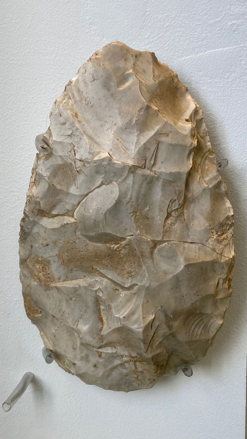
However, earlier circumstantial evidence of a human presence in Britain has been discovered in East Anglia. Stone tools and a preserved trail of footprints, thought to belong to Homo antecessor, indicate that early humans were roaming Ancient Britain c. 950,000 years ago. The arrival of the Anglian glaciation c. 450,000 years ago – the most extreme glaciation in the last million years – made human survival in Britian impossible. The absence of humans lasted millennia until Neanderthals began sporadically hunting on the vast prairies of Ancient Britain between c. 400,000-50,000 years ago, as and when the climate allowed. A female jaw fragment found in a cave in Devon is the earliest fossil evidence of modern humans found in Britain dating the arrival of Homo sapiens to, at least, 40,000 years ago. Again, climatic conditions meant their presence was sporadic, only becoming continuous at the end of the last ice age (c.12,500 years ago). Palaeolithic hand axes and flint tools have been found in Litlington, Westdean, Exceat and Arlington mainly spanning the Lower to Middle Palaeolithic, possibly dating as far back as 500,000 BC. Examples of these are held in the museums of Lewes, Eastbourne and London, as well as the British Museum and the Ashmolean in Oxford.
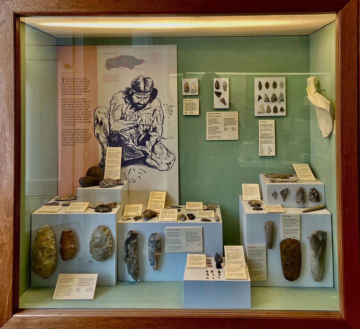
Palaeolithic hand axes and flint tools have been found in Litlington, Westdean, Exceat and Arlington mainly spanning the Lower to Middle Palaeolithic, possibly dating as far back as 500,000 BC. Examples of these are held in the museums of Lewes, Eastbourne and London, as well as the British Museum and the Ashmolean in Oxford.
Continuous human occupation of Britain began during the Mesolithic (c. 10,500 BC – 4,000 BC). As the climate began to warm at the end of the last ice age, the bleak, treeless landscape of Sussex gradually transformed into one of open-wood pasture attracting the first groups of Mesolithic hunter-gatherers from the Continent. Recent research suggests that returning herds of grazing megafauna – like the aurochs (the wild ox), tarpan (the original wild horse of Europe), wisent (the European Bison) and elk – created a more open landscape than closed canopy forest, as previously thought. This mosaic of grassland, scrubland, groves and solitary trees supported a huge biomass of animals (far more than closed canopy forest). Small pieces of flint (microliths), that would have been set into wood to make spears and harpoons, have been found locally. These tools enabled Mesolithic hunter gatherers to exploit the Cuckmere Valley’s teaming grasslands and wetlands.

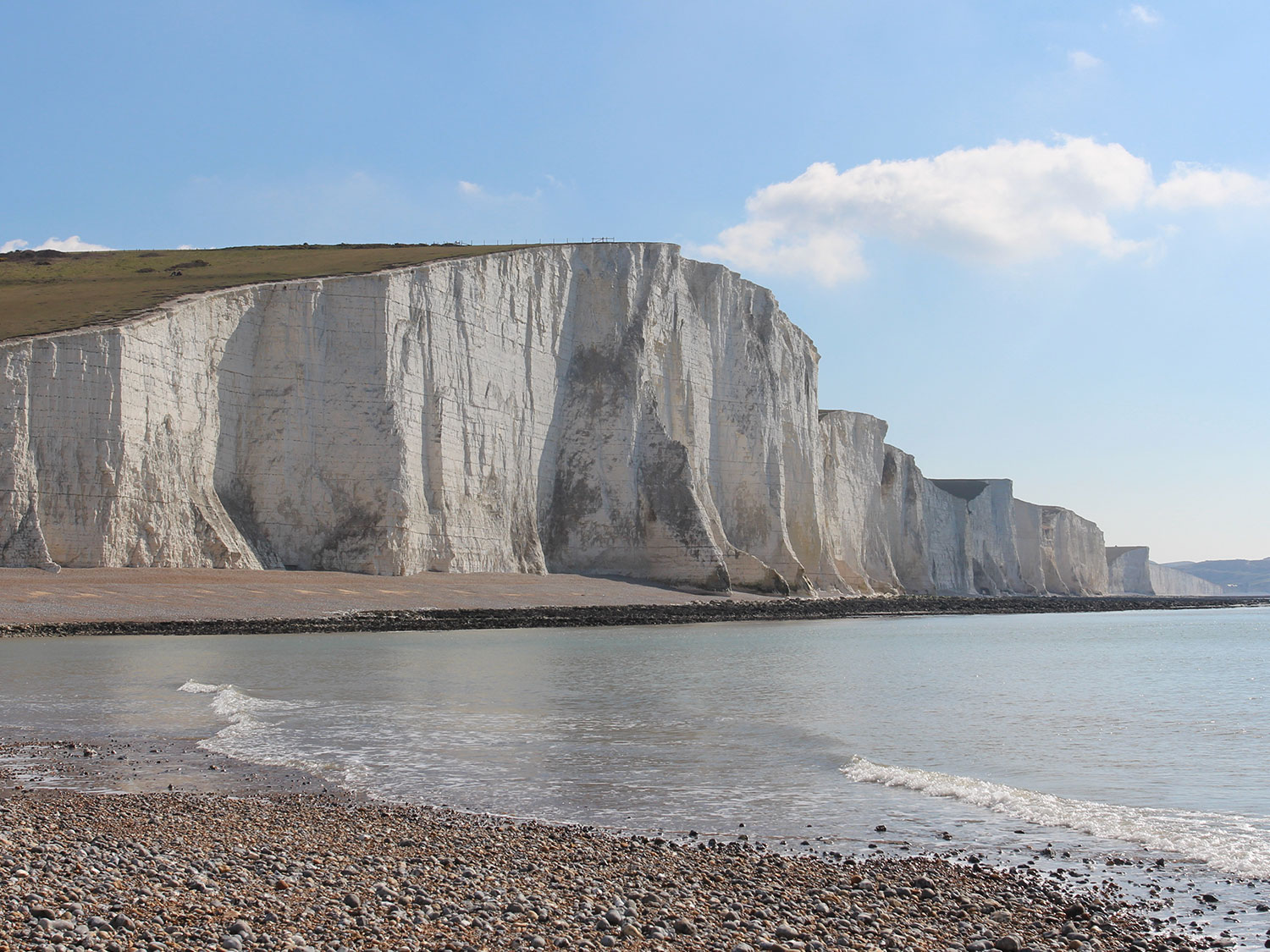
During the Mesolithic, rising sea-levels finally inundated the low-lying land connecting present day Britain to Europe. The end of the last ice age saw the slow release of melt water previously locked up in glaciers and ice sheets. This long-term trend combined with two sudden natural disasters around 8,200 years ago: a catastrophic release of water from a North American glacial lake and a tsunami caused by a submarine landslide off Norway. Sussex was severed from the Continent by the formation of the Channel. Where the Chalk Downs dipped into valleys sheer white cliffs were formed, the Cuckmere’s Seven Sisters being among the most famous. An estimated population of about 5,000 hunter gatherers stranded on the newly formed British Isles gradually increased over the coming millennium owing to continued warming and improved technology. The late Mesolithic saw the expansion of food-rich marshlands and, possibly, migrants crossing the Channel from Europe bringing new tools and agricultural skills. Composite flint hand tools unearthed in the orchard at Westdean tell of the very earliest Mesolithic farming communities living in the Cuckmere Valley 7,000 years ago. Although these early cultivators grew pulses, barley and wheat on the chalk downland, they still relied on wild food and resources. Rather than settle in one place these semi-nomadic people tended to move around within designated territories with some evidence of more permanent settlements.
Settled farming was gradually introduced to the Cuckmere Valley during the Neolithic (c. 4,000 BC – 2,400 BC) with evidence of domesticated animals and cereal crops, flint mines and settlements scattered across the Downs. Hunting, fishing and the gathering of berries, fruit and nuts continued alongside farming – as it does today. Traces of these Neolithic people are most numerous on the summits and slopes of the Downs which were easier to clear and cultivate than the valley’s marshland or the forested, boggy Weald to the North. They were probably the first to domesticate animals, reverting to full-time hunting and fishing when times were hard. Composite flint tools (serrated blades, axe heads and scrapers) were used for most everyday tasks and flint mining was industrialised. Neolithic flintwork has been found near Alfriston and on Lullington Heath with evidence of flint mines on Windover Hill. A Neolithic flint-making pit was uncovered in 2009 when the Norman Dovecote at Westdean was conserved. Alongside stone tools, pottery began to appear, especially pots for storing, cooking and eating food. This era also saw the development of sacred landscapes with territories focused around large communal monuments such as circle henges, earth mounds and long barrow burial sites. Advancements were also made in home construction, art, sewing and weaving. Neolithic hand axes and flint tools have been found in Litlington, Westdean, and Arlington.
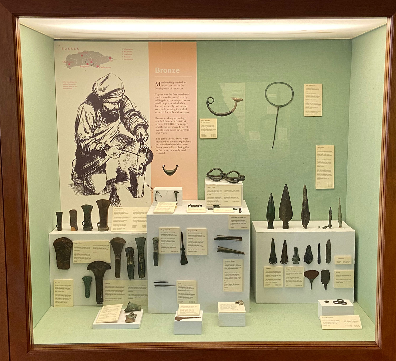
The British Bronze Age (c. 2,400 BC to 800 BC) was heralded by the arrival of the Beaker people on British shores, most likely from Central Europe. They brought with them a distinctive style of pottery (notable for their bell-shaped beakers) and the skill of metallurgy. Integration with the Neolithic farmers is thought to have been relatively peaceful and cultural exchange significant. Initially, weapons, implements and jewellery were made from copper but around 4,000 years ago smiths had discovered how to make the first alloy, bronze, by mixing copper with a small amount of tin. Bronze was harder than copper and easier to work with. Over the next 1000 years bronze gradually replaced flint as the main material for tool and weapon making. The clearance of the Downs proceeded apace. Ox-drawn ploughing was introduced and in the mid to late Bronze Age the landscape was divided up by a complicated field system that lasted for many hundreds of years. Permanent roundhouses were built, often grouped into villages, and the first hillforts were constructed suggesting the emergence of social elites and armed conflict. During the Bronze Age individual graves covered with round barrows and filled with valuable possessions began to replace the communal Neolithic long barrows. Numerous Bronze-Age burial mounds are dotted along the Cuckmere Valley at high points on the Downs overlooking the river valley below.
Recent archaeological research has found little evidence that Celtic invaders from mainland Europe ushered in the British Iron Age (c. 800 BC to 43 AD), as previously thought. It is more likely that a series of migrations and cultural diffusion via trading links with the Continent influenced indigenous socio-economic change. This was particularly the case in South East England. Iron artefacts gradually replaced those of bronze becoming widespread by about 500 BC. Unlike tin, needed to make bronze, iron ore was much more readily available allowing weapons and tools to be made more cheaply in larger numbers. Higher quality bronze weapons were reserved for nobles and royalty. New and improved varieties of crops, farming methods and technologies (iron-tipped ploughs and iron reaping hooks) led to a population boom. Extensive field systems (Celtic fields) were set out and settlements of lowland farmsteads and roundhouses became more focused on better exploitation of the land. On the slopes of the South Downs, lynchets were formed by the deliberate ploughing each year of the same furrow. These terraces (on steep slopes) or raised banks (on more gentle inclines) created a level area of deep soil for planting, superior to the surrounding shallow earth. Two large terraces can be seen to the east of the Cuckmere at Exceat, and smaller ones are visible on Lullington Heath and the hillsides above Deep Dean. As settlement density increased, particularly in the South East, a more structured tribal system emerged and the chalklands of Sussex were divided into regions. Massive hilltop forts were constructed, such as that at Seaford Head (now mostly fallen into the sea), used as much for industry, markets, food storage and social contact as defence. Towards the end of the Iron Age, there was growing contact with the Roman Empire which had extended to Gaul (modern France). Roman economic and cultural influence was particularly strong in Southern England where coinage and the potter’s wheel were adopted. Late Iron Age pottery has been found to the west and south of the site where the Plough & Harrow Pub now stands suggesting small farmsteads had probably developed along the valley edges.
Each of these different ages did not suddenly begin when one ended, but each fused and overlapped one with another.
The Roman conquest and occupation of England and Wales (AD 43 to AD 411) was a gradual process beginning under Emperor Claudius and largely completed by AD 87 when Hadrian’s Wall was established as the northern frontier. It is estimated that the forty-year military conquest saw between 100,000 to 250,000 Britons killed out of a population of two million, a very high figure for pre-industrial warfare. Following the conquest, a distinctive Romano-British culture emerged as the Romans introduced improved agriculture, urban planning, industrial production, arts, crafts and architecture. More advanced ploughs were used on large estates worked by slaves or serfs. Ironworking was increased with many Roman smelting sites unearthed in the Cuckmere area. These would have been fuelled by coppicing and managed woodland. Watermills were also constructed along the Cuckmere for the first time. As accomplished road builders, the Romans built crossings of the Cuckmere at Exceat and Chilver Bridge establishing several coastal routes to the Roman fortress at Pevensey. Prior to the thirteenth century, the Cuckmere was a broad, marsh-edged expanse of water that likely supported substantial river traffic between Weald and Coast, at least as far as Arlington. Arlington was an important Roman settlement, possibly the site of shipbuilding and a Roman temple where the parish church now stands. Roman pottery and the site of a potter’s workshop at Polhill’s Farm were discovered during the construction of Arlington Reservoir. Sussex would have benefited enormously from increased trade with the Continent. Local evidence of this affluence can be found in the remains of large, comfortable villas built by Romans and Britons alike. During this time of prosperity in the second century, the Roman province of Britannia came to be personified as a goddess armed with a trident and shield and wearing a centurion helmet. The cultured and colonial style of living created by the Romans lasted until early in the fifth century when the Roman army left to defend Rome against invaders from the East. The Romano-British were left to defend Britain against a new wave of settlers: Saxons from the Baltic coast.
Around AD 450 the seas were still rising as glaciers from the last ice age continued to melt. As a result, low-lying countries in Northern Europe were losing significant territory to flooding. Historians are not sure if the Anglo-Saxon conquest of England (AD 43 to 410) resulted solely from Saxons looking to conquer new land to farm as a result of this displacement, or if Britons also encouraged them to settle to help defend against invaders from Scotland and Ireland. The main Saxon incursion into the Cuckmere region, led by Aella, probably took place around AD 457, when Britons were displaced to the forests of the Weald. The breaking of the treaty of Meacredesburna in AD 465 led to a battle and Saxon victory, most likely at the Neolitihic fording point of the Cuckmere River opposite Milton Street. The South Saxons were most successful in Sussex and gave the county its name. Early on they settled in small extended family groups high up on the Downs. It was not until the seventh century that archaeologists have identified clusters of occupation locally that resemble a village layout. A sizeable Saxon cemetery serving such a settlement was unearthed at Winton Street in Alfriston in 1912 by builders digging foundations for a new house. Five generations were identified from a settlement of 30-40 people living between AD 475-625. A high-ranking military family were among the dead, the men buried with shields and spears and the women with some of the richest Saxon jewellery yet found in East Sussex. Buried with the most extravagant items, one of these high-ranking women had a terrible deformity and cannot have moved unaided. Following a tubercular illness in her youth her left thigh had fused to her pelvis. The leg remained fixed in its torturous position, her left knee ever resting on her right hip.
The Saxons continued to clear the Wealden forests like their Roman, Iron and Bronze Age predecessors. The word ‘weald’ is derived from the Saxon word ‘wold’ meaning forest. They maintained the Bronze age ‘linear landscape’ that divided land into strips running west to east down the valley, so that each family had a share of downland grazing, lower arable land and river meadows. The Saxons called these strips hides. Interestingly, the line of the footpath from Litlington to Frog Firle – Cow Lane – is of great antiquity. It represented the boundary between two Saxon ‘hundreds’ or districts.
Christianity reached Sussex around AD 680 and there was considerable conflict before pagan traditions of ancestor worship and graveside memorial feasting were finally abandoned. The new priests were directed to construct churches on pagan burial grounds which may have sparked local resistance. St Wilfrid, an exiled northern bishop who established himself in Sussex in the seventh century, was influential in establishing Christianity locally.
In the late Saxon period, fortified settlements or burghs (the forerunner of our boroughs) were built to counter Viking raiders from Scandinavia. By the beginning of the eleventh century the Vikings had subdued the north of England and Canute of Denmark became King of England. Seven years after his death, a Saxon prince, Edward the Confessor, was elected King. King Edward owned substantial land in the Cuckmere Valley, comprising three manors at Exceat, two at Westdean and one at Charleston. He also owned Berwick and Claverham and part of Frog Firle on the western side of the river.
The Saxons ruled for around a hundred years more than the Romans, and unlike the Romans they never left. Many people living in Britain today have Anglo-Saxon ancestors. The name England even comes from the Saxon word ‘Angle-Land’.
The Norman conquest of England in 1066
When Edward the Confessor died in 1066, his brother-in-law, Harold Godwinson, assumed the throne on behalf of the Anglo-Saxons, usurping William, Duke of Normandy, a relative whose hopes may have been encouraged by the childless King Edward. The Duke of Normandy and his army of Norman, Breton, Flemish and French soldiers landed at Pevensey, and the subsequent Battle of Hastings resulted in William being crowned King of England on Christmas Day 1066. Sussex was the front-line of this sea-borne invasion and the security of the Channel ports was important to William because of his need to maintain links with Normandy. William moved fast to secure his kingdom. He placed his half-brother Robert, Count of Mortain, as overlord of the region known as the Rape of Pevensey, which included the Cuckmere Valley. At first the priority was to protect the coastline while the invaders proceeded inland. Mortain placed some of the highest-ranking members of the original invasion force along the Cuckmere Valley to exert control over the local area and protect this vulnerable coastline. These tenants-in-chief were given large holdings of land in exchange for services and fealty. One Norman lord named Ralph, who became progenitor of an important Sussex family, the Denes, was given the manor of Westdean. Another Norman, Ralph the Earl was given the manor of Cerlestone (Charleston), which was later held by Alured, William the Conqueror’s Cup Bearer. Only one of the Saxon ruling class retained his Cuckmere estate at Exceat, a man called Heming.
Much of what we know from this era comes from the Domesday Book of 1086, a manuscript record of the ‘Great Survey’ of much of England and Wales compiled to record the victor’s new possessions. It also records landownership before the Normans arrived under Edward the Confessor, listing the Saxon thanes (lords) and their hides of land (the amount of land needed to sustain one family). Essentially, a list of tax due to William the Conqueror, it records the taxable value of property under King Edward, its value after the Conquest of 1066, and its value 20 years later in 1086. The entry for Westdean says that Azur held a manor of eight hides from King Edward before the Conquest valued at £7. After the Conquest its value dropped to 60 shillings so we can assume it was quite heavily depredated by the invading forces. In 1086, it had recovered a little to a value of 100 shillings and was held by the Norman lord, Ralph, from the Count of Mortain. The Domesday Book doesn’t refer directly to Litlington or Lullington by name as these were outliers of larger estates. Lullington was part of the wealthy Saxon manor of Alciston owned by a Kentish noble, Aelnoth of Canterbury. Aelnoth was a figure of sufficient importance in the Saxon hierarchy to be taken as hostage by William the Conqueror when he had to return briefly to Normandy after the Conquest. He was dispossessed of his lands. Litlington was part of the holdings of the one-time Saxon church minster (or monastery) of Bishopstone.
The Normans brought with them from France a new culture and high standards. Their builders were more confident than the Saxons creating sturdier, bolder churches and castles. The Norman influence continued for centuries eventually integrating with the blend of peoples and cultures that had come before them. Thousands of French words entered the Old English, or Anglo-Saxon, language at this time. The Normans were the last successful invaders of England.